Published on February 17, 2026
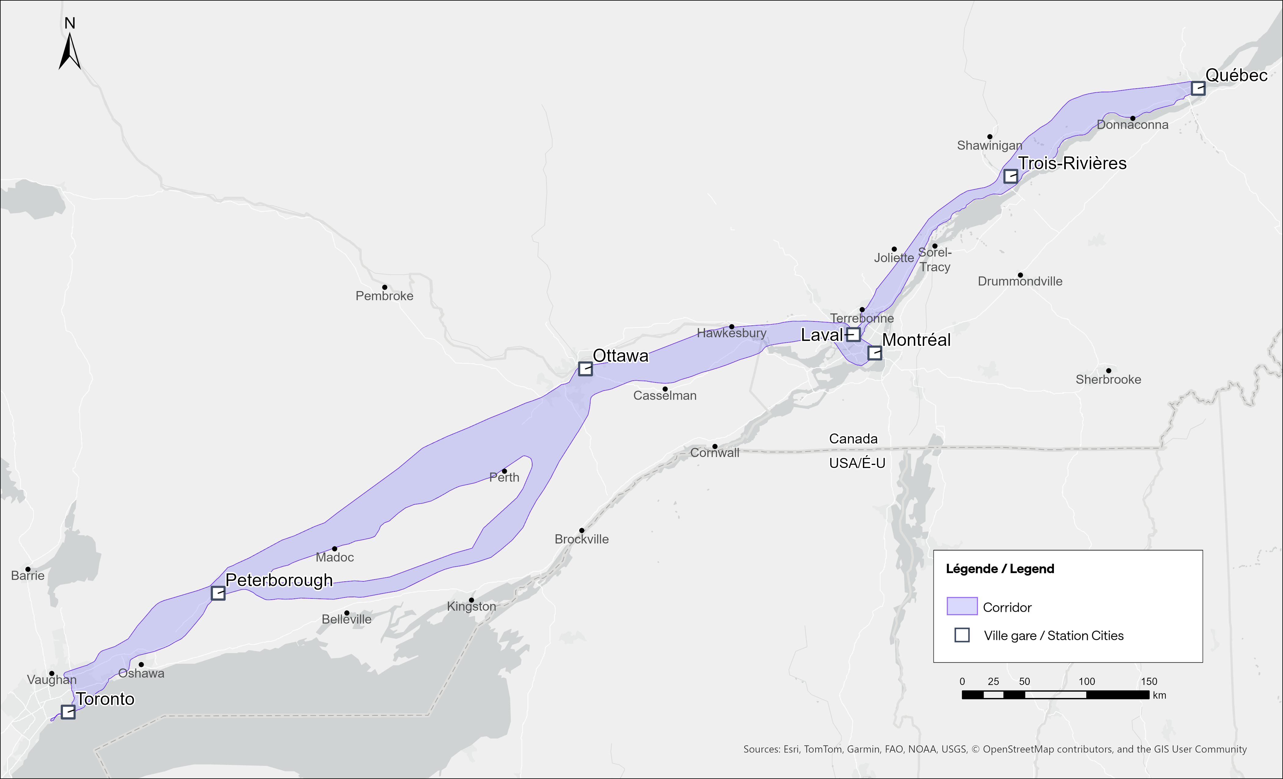
Since the start of public consultations on the future Québec City–Toronto high-speed rail network in January, we have been asked a number of questions about the proposed corridor for this major project. Let’s dive deeper.
The corridor as a first step
First, let’s distinguished a corridor from an alignment. The corridor is a preliminary and important step in determining the Alto train’s final alignment (or route). Approximately 10 kilometres wide, it will be subsequently refined to determine where the rail network’s right-of-way—about 60 metres wide—will actually be located. However, we have to go through several steps before we get there.
Alto chose to consult early in the process. As a result, discussions are currently focused on a corridor rather than predetermined route options. A much narrower corridor covering the Montréal–Ottawa segment will be discussed in the next consultation phase in late 2026.
The route: working with communities
In order to determine the best route, we will consider a set of factors, including technical analyses, feedback from the public, Indigenous groups and surrounding communities, the field study results, and the conclusions of environmental assessments.
That route is the key to ensuring the future Alto train’s speed and efficiency. It must plan for long, straight segments and gentle curves to allow the train to achieve a high cruising speed.
While focusing on performance, we will also strive to reduce the impact on surrounding communities. To that end, the proposed corridor includes existing infrastructure that the network will follow where possible.
Next step: field studies
Field studies continue along the first segment. Alto will contact communities and landowners in advance to obtain access to their properties. Owners who agree to welcome our teams will be compensated. They will also be able to refuse, as participation in these studies is entirely voluntary.
Being contacted by Alto for field studies doesn’t mean that your property is on the planned route or that an acquisition is planned. Instead, study sites are chosen to reflect various environments near the future network.
Only once the route is finalized will we know what land will have to be acquired to carry out the project. At this stage, the team will seek to enter into agreements with the owners. While expropriations may be necessary, this is not the preferred option. Our approach will foster transparency and negotiation to establish fair compensation.
Make your voice heard
Want to share your feedback? Take part in one of our public consultations in person or online, or speak out through our consultation platform. The project will also undergo a federal environmental assessment under the Impact Assessment Act. This will be another opportunity for the public to access detailed information on the project’s impacts and provide feedback.
To stay informed about the project’s progress:
- Sign up for our newsletter
- Follow Alto on LinkedIn and Facebook
Share this blog post
Subscribe to the blog RSS feed