

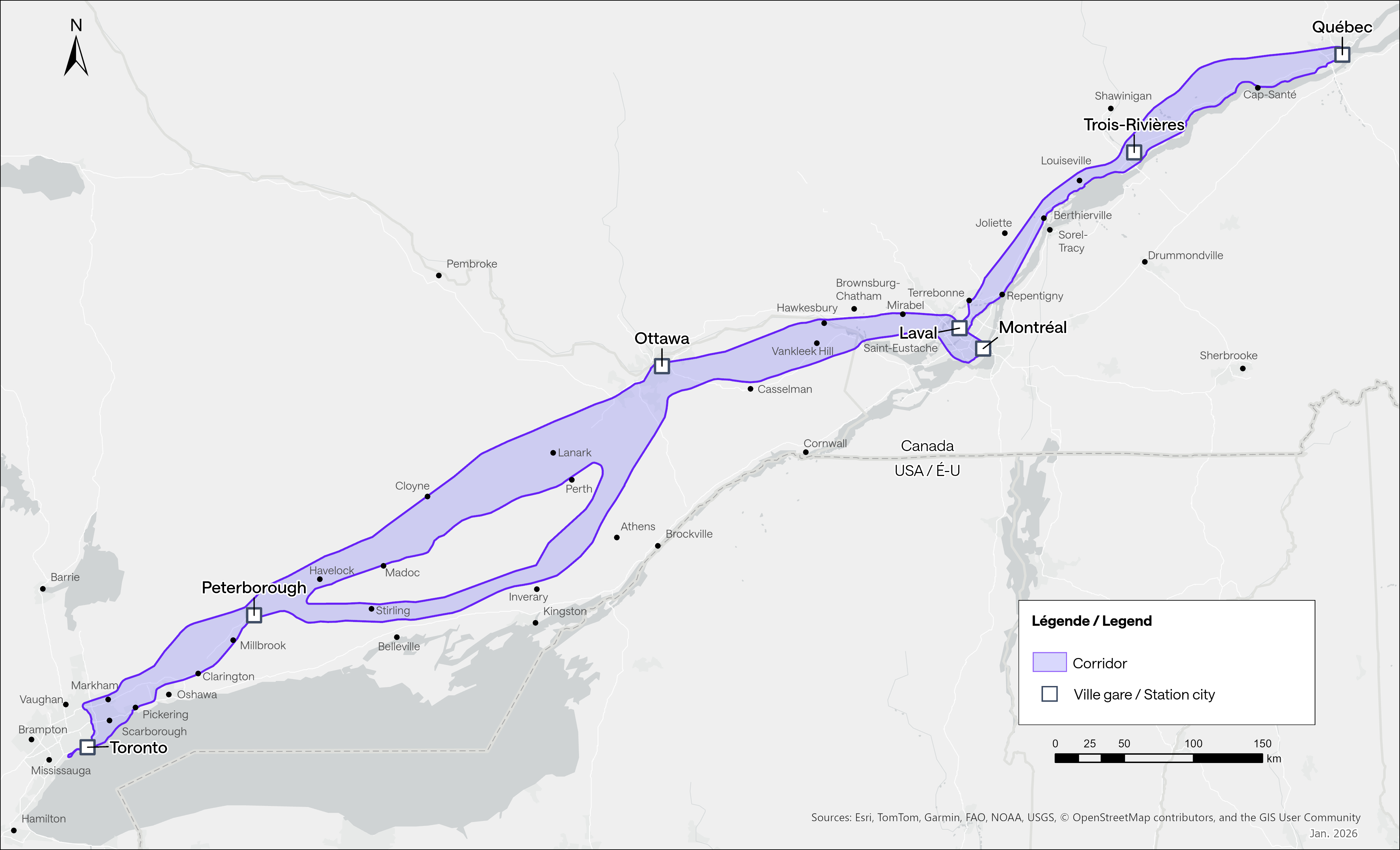
The Toronto–Québec City study corridor extends close to 1,000 kilometres and represents a zone approximately 10 kilometres wide within which Alto is exploring various possibilities for developing a high‑speed rail network. At this stage, it is not a defined route, but rather a study area being analyzed to identify route options with the strongest potential while limiting impacts. Ultimately, the rail network will require a right of way with an average width of approximately 60 metres.
The corridor will be progressively refined as technical and environmental studies advance and as feedback is considered from consultations with citizens, Indigenous communities, civil society and all levels of government. This gradual approach is intended to support the development of a high‑performance project that is well integrated into its surroundings and socially responsible.
Factors guiding the development of the corridor
The corridor analysis is based on several complementary criteria:
- Technical: designing the most direct alignment possible, without level crossings, to ensure train performance, safety and high speeds.
- Environmental: reducing impacts on agricultural lands, natural and sensitive environments, including species at risk.
- Social: minimizing proximity to populated areas wherever possible.
- Urban planning: foster harmonious integration into the environment, notably by using existing linear infrastructure such as highways, rail lines and power corridors.
- Financial: optimizing construction and operating costs while supporting future ridership.
These criteria serve as a basis for comparing and refining the various options within the corridor during the development and pre‑construction phase.
Phases of construction
The central segment connects Ottawa and Montréal and will be the first section of the network to be built.
The journey begins in Ottawa, where the locations studied for the station focus on areas that are well connected to existing transportation networks and have sufficient space to accommodate a high‑speed rail station. Surface‑level Alto stations require approximately 42,000 m². The objective is to facilitate passenger access while considering existing urban constraints.
As the corridor leaves Ottawa heading east, the analysis aims to limit impacts on existing neighbourhoods by relying, where possible, on existing linear infrastructure such as highways, railways and power transmission lines. This approach also helps reduce the corridor’s footprint in surrounding agricultural, forested and recreational areas.
To cross from Ontario into Québec, studies are focused on the construction of a rail bridge overs the Ottawa River at a narrow point.
On the Québec side, the corridor continues along the north shore of the Ottawa River, again favouring proximity to existing infrastructure to limit impacts on agricultural and forested areas in Outaouais and the Laurentians regions.
As the corridor approaches Laval, it enters more densely populated areas where space constraints are significant. The station location has yet to be determined but will need to allow for strong integration with public transit networks.
Access into Montréal represents a greater challenge. Structuring solutions, such as a tunnel under the Rivière des Prairies and Mount Royal, are being studied to reach downtown directly while limiting impacts in a dense urban environment. The station, envisioned in the Ville‑Marie borough, could be located at grade or underground.
The journey begins in downtown Toronto, where several areas are being studied for the future station. Union Station and its surroundings offer strong potential in terms of connectivity and accessibility. Other locations east or west of the downtown core are also under analysis, provided they offer sufficient space and effective integration with existing transportation networks.
Leaving downtown, Toronto presents significant challenges due to urban density. Northern and eastern options are being studied, relying on existing corridors or solutions such as tunnels or elevated tracks to reduce impacts. As the corridor crosses the Greater Toronto and Hamilton Area, its width and the presence of existing infrastructure are favourable elements to consider.
Heading east, the corridor leaves the Toronto region toward Peterborough, crossing industrial and agricultural areas. Railway corridors, highways and utility corridors provide opportunities to limit the project footprint. In Peterborough, the station could be located near major roadways, with connections to bus services.
Between Peterborough and Ottawa, two main approaches are being analyzed: a more direct northern corridor crossing less populated areas of the Canadian Shield, which presents greater technical challenges, and a more southern route through agricultural and recreational areas, which would facilitate construction and operations while crossing more densely settled regions. In both cases, the objective remains to reduce impacts on agricultural, forested and recreational environments.
Leaving Montréal, the corridor travels toward the North Shore via the Laval station, then continues east. Where possible, analyses favour proximity to existing linear infrastructure to reduce impacts on urbanized areas and natural environments. To leave the island of Laval, a rail bridge will be required to cross the Rivière des Mille‑Îles.
Upon entering Lanaudière, the corridor passes through residential areas where space constraints remain significant. Continuing east, the route follows the north shore of the St. Lawrence River toward Trois‑Rivières, crossing primarily agricultural and natural areas. Studies focus on alignments near highways or existing railways to reduce the footprint of the network.
In Trois‑Rivières, station locations under consideration prioritize accessibility and coherent integration into the urban fabric. To leave the city toward Québec City, northern approaches are being studied, given constraints related to existing rail infrastructure and the density of the downtown core.
On the way to Québec City, the corridor crosses regions such as Mauricie, Portneuf and La Jacques‑Cartier. In these predominantly agricultural and natural areas, attention is focused on limiting impacts on agricultural properties and sensitive environments.
For the approach into Québec City from the west, analyses concentrate on existing highways and railways where possible, as high‑speed rail requires very straight alignments. In urban areas, the objective is to limit impacts on residential neighbourhoods and private properties. Québec City’s station will be located in an area well connected to existing transportation with sufficient space.
Specialized infrastructure adapted to the environment
Alto’s network will be designed to integrate thoughtfully into the environments and communities along its route. The objective is clear: limit impacts on communities near the network and preserve ecosystems, while ensuring service performance and safety.
Our network will use specialized infrastructure adapted to the diverse environments and geographic conditions it passes through.

Network features
- Railway right-of-way that is approximately 60 metres wide for maintenance and safety
- Service roads for use by service and response vehicles
- Elevated tracks to limit the footprint and preserve local mobility
- Bridges and overpasses that meet environmental standards
- Strategically located maintenance centres
- Well-integrated stations as mobility and urban development hubs
- Tunnels to cross densely built areas or natural obstacles
High-speed rail components
High-speed rail has proved itself worldwide, including in France, Japan and Spain. These networks are known for being efficient, safe and for improving connectivity between cities.
Alto draws on these models while also considering Canadian realities to design a system that is reliable, efficient and adapted to our climatic conditions.
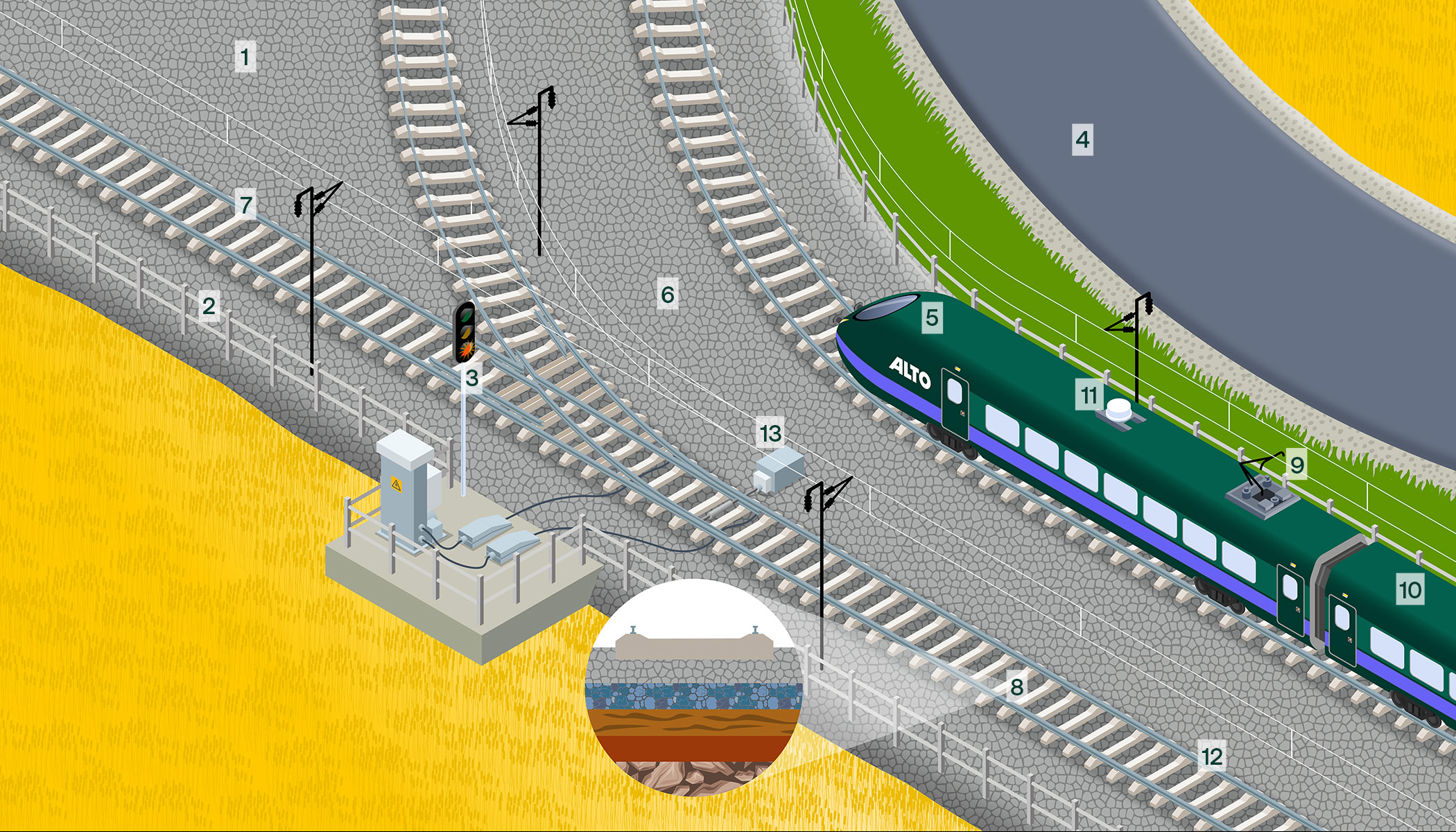
High-speed rail is one of the world’s safest modes of intercity transportation. Alto will adopt best practices to ensure passenger and community safety.
- Dedicated tracks without any railway crossings
- Security fencing to prevent trespassing
- Advanced signalling systems and automated controls
- Service road for train access and maintenance.
A train must reach speeds of approximately 250 km/h or more to be considered high-speed.
Alto will leverage advanced engineering, specialized infrastructure and operational strategies to achieve speeds of 300 km/h or more.
- Aerodynamic train design and lightweight materials
- Track geometry optimized to maximize linear segments and limit curve amplitude (minimum radius of 7 km)
- Ballasted railway track, where the track is secured to ties that rest on a layer of crushed rock ballast
- A railway platform consisting of compacted layers under the ballast to support and ensure the long-term stability of the tracks.
Reliability and comfort are key to providing an enhanced travel experience.
- Catenary and pantograph power supply
- Spacious cabins
- Efficient Wi-Fi
- Welded tracks to reduce noise and vibrations
- Switch heaters and track components suited to winter conditions.